Spitsbergen is one of those places that often sparks curiosity due to its remote location and icy environment. If you look at a world map, you may have to zoom far into the Arctic region to find it. While not as commonly discussed as popular global landmarks, its geographical significance, Arctic wildlife, and history make it an interesting subject. Knowing where Spitsbergen is on the world map not only satisfies a geographical curiosity but also helps in understanding the environmental and geopolitical importance of this Arctic region.
Location of Spitsbergen on the World Map
Spitsbergen and the Svalbard Archipelago
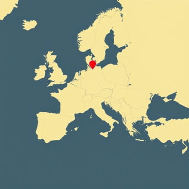
Spitsbergen is the largest island of the Svalbard archipelago, which belongs to Norway. Located in the Arctic Ocean, Spitsbergen is situated far north of mainland Europe. On a world map, you can find it well above the Scandinavian Peninsula, specifically north of Norway.
Geographic Coordinates
The approximate coordinates of Spitsbergen are between 76° and 80° North latitude, and 10° to 25° East longitude. These coordinates place it well within the Arctic Circle, making it one of the northernmost inhabited places on Earth.
Nearby Countries and Landmarks
When pinpointing Spitsbergen on a global map, the following geographical references can be helpful
- North of mainland Norway
- East of Greenland
- West of Russia’s Franz Josef Land
- Northwest of mainland Russia
It is also located roughly halfway between the northern coast of Norway and the North Pole, making it a strategic and scientific location for Arctic research.
Political and Administrative Context
Part of Norway
Though Spitsbergen is far removed from Norway’s mainland, it is administered as part of the Kingdom of Norway. It falls under the Svalbard Treaty of 1920, which recognizes Norwegian sovereignty while also granting certain rights to other signatory countries. On political maps, Svalbard, with Spitsbergen as its largest island, is typically labeled under Norway’s domain, despite its distant Arctic location.
Svalbard Treaty Area
Spitsbergen’s legal and political status is unique. The Svalbard Treaty allows citizens of certain countries to settle and engage in commercial activities. This has resulted in the presence of Russian mining towns like Barentsburg, alongside Norwegian settlements like Longyearbyen. Maps detailing political regions often denote this treaty area distinctly from mainland Norway due to its special governance.
Major Settlements Visible on Maps
Longyearbyen
The capital and largest settlement on Spitsbergen is Longyearbyen, located on the western coast of the island. On detailed maps of Spitsbergen, Longyearbyen is clearly marked and serves as a hub for transportation, tourism, and scientific research in the Arctic.
Barentsburg and Ny-Ålesund
Other notable locations on the map of Spitsbergen include
- BarentsburgA Russian mining town, the second-largest settlement on the island.
- Ny-ÅlesundOne of the northernmost permanent civilian settlements, used mainly for scientific research.
Geographic Features on a Physical Map
Mountains and Glaciers
Spitsbergen is known for its rugged terrain, with mountainous regions and deep fjords. Physical maps of the island show prominent mountain ranges like the Atomfjella and glaciers such as Austfonna and Kongsbreen. These features make Spitsbergen an ideal location for studying glaciology and climate change.
Coastal Landscape
The island’s coastline is deeply indented with fjords, making it resemble the fjord-ridden coast of western Norway. Maps that emphasize elevation and water features will clearly outline these fjords and coastal bays. Spitsbergen’s west coast is more accessible and has milder conditions due to the influence of the North Atlantic Current.
Climate and Arctic Environment
Arctic Climate Zones
Because of its high latitude, Spitsbergen experiences an Arctic climate with long, cold winters and short, cool summers. Climate zone maps mark this region as part of the polar climate zone, often highlighted in shades of blue or gray to indicate low temperatures and snow coverage.
Polar Day and Night
Spitsbergen is one of the few places on Earth where you can experience the phenomenon of the Midnight Sun and Polar Night. For several months during summer, the sun never sets, and during winter, it does not rise. These features are noted on climatological and astronomical maps of the Arctic Circle.
Scientific Importance and Presence on Research Maps
Research Stations and Projects
Spitsbergen is a key location for Arctic research. Longyearbyen and Ny-Ålesund host numerous scientific institutions, and these locations are prominently displayed on specialized scientific and polar research maps. The island serves as a base for research in glaciology, polar biology, atmospheric sciences, and astronomy.
Svalbard Global Seed Vault
One of the most notable facilities on the island is the Svalbard Global Seed Vault, which stores seeds from around the world as a global backup. This location appears on environmental and agricultural maps focused on biodiversity preservation.
Transportation and Accessibility on the Map
Air and Sea Routes
Though remote, Spitsbergen is accessible by air and sea. Maps of Arctic transport routes often show flights connecting Longyearbyen with cities like Oslo and Tromsø. There are also maritime routes used by research vessels and occasional cruise ships during summer months.
Internal Transportation
Within the island, transportation is limited to snowmobiles in winter and boats in summer, as there are very few roads connecting settlements. This lack of infrastructure is visible on detailed topographic maps of the region, where roads are sparse and isolated.
Spitsbergen’s Role on Thematic World Maps
Climate Change and Environmental Monitoring
Due to its location and environment, Spitsbergen often appears on thematic maps related to climate change. Ice coverage, glacial retreat, permafrost monitoring, and Arctic sea ice dynamics are all areas where Spitsbergen plays a vital role.
Biodiversity and Wildlife
Ecological and biodiversity maps highlight Spitsbergen’s importance as a habitat for polar bears, Arctic foxes, reindeer, and various seabirds. Marine maps show the presence of whales and seals in the surrounding Arctic waters.
Spitsbergen, the largest island of the Svalbard archipelago, is located in the Arctic Ocean, north of mainland Norway. On the world map, you will find it far above the Scandinavian Peninsula, near the top of the globe, within the Arctic Circle. Its unique position gives it importance not only in geographical terms but also for climate research, environmental conservation, and Arctic governance. Whether viewed through political, physical, or thematic lenses, Spitsbergen holds a vital place on the world map, acting as a symbol of humanity’s reach into the most extreme corners of the planet.