When learning about directions, navigation, or surveying, two common systems appear quadrant notation and azimuth notation. These two approaches describe bearings and angles relative to reference directions, but they operate in different ways. Quadrant notation relies on dividing the compass into four sections, while azimuth notation uses a continuous degree system from north. For students, professionals, or outdoor enthusiasts, understanding how to convert quadrant notation to azimuth notation is essential, as many fields such as land surveying, civil engineering, and navigation often require switching between them depending on context. This topic explains in detail what each system represents and how to perform conversions effectively.
Understanding Quadrant Notation
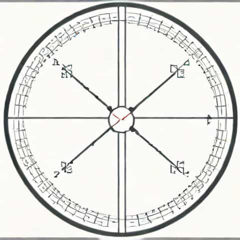
Quadrant notation is a system that divides a circle into four quadrants northeast, southeast, southwest, and northwest. Instead of describing a direction with a single number, it combines an angle with a reference to north or south followed by east or west. This makes it easy to visualize but sometimes less efficient for precise calculations.
Features of Quadrant Notation
- Angles are always measured from either north or south.
- The maximum angle within each quadrant is 90 degrees.
- A direction is expressed as, for example, N40°E, meaning 40 degrees east of north.
- Four quadrants exist N-E, S-E, S-W, and N-W.
This notation is common in navigation and older surveying practices, as it is intuitive and immediately shows which quadrant the direction lies in. However, it can sometimes cause confusion when working with precise data or mathematical models.
Understanding Azimuth Notation
Azimuth notation, by contrast, is more straightforward for calculations. It uses a 360-degree circle starting from north and measuring clockwise. Every possible direction is described by a unique degree value, eliminating the ambiguity of quadrant-based systems.
Features of Azimuth Notation
- Measured clockwise starting from north.
- Ranges from 0° (north) through 90° (east), 180° (south), 270° (west), and back to 360° (north).
- No need to mention north or south explicitly since the degrees already capture the direction.
- Commonly used in modern surveying, GIS (Geographic Information Systems), and military navigation.
The main advantage of azimuth notation is its clarity and consistency, especially when integrated with technology or mathematical calculations. For example, an azimuth of 135° always points southeast, regardless of context.
Converting Quadrant Notation to Azimuth Notation
The process of converting quadrant notation to azimuth notation requires understanding which quadrant the direction lies in and then adjusting the angle accordingly. The rules are systematic and can be summarized as follows
Conversion Rules
- NθEAzimuth = θ (because the angle is measured clockwise directly from north).
- SθEAzimuth = 180° − θ.
- SθWAzimuth = 180° + θ.
- NθWAzimuth = 360° − θ.
For example, if the quadrant notation is N40°E, the azimuth is simply 40°. If it is S20°E, the azimuth becomes 160°. For S45°W, it translates into 225°. Finally, N30°W would be 330°.
Practical Examples
To solidify the concept, let us look at a few more examples of conversion
- N15°EAzimuth = 15°.
- S70°EAzimuth = 180° − 70° = 110°.
- S10°WAzimuth = 180° + 10° = 190°.
- N80°WAzimuth = 360° − 80° = 280°.
These examples demonstrate how every quadrant notation has a corresponding azimuth, making it possible to switch between systems smoothly. Once the rules are memorized, the process becomes second nature.
Applications of Conversion
Knowing how to convert quadrant notation to azimuth notation is not just an academic exercise. It has real-world applications in multiple fields where precision in direction is essential.
Surveying and Civil Engineering
In surveying, bearings are often recorded in quadrant notation, especially in older maps and property descriptions. However, modern surveying equipment usually uses azimuth notation. Professionals must convert between them to ensure consistency and accuracy.
Navigation and Outdoor Activities
Hikers, sailors, and pilots may encounter both systems depending on the source of their maps or navigation charts. A compass might use quadrant bearings, while GPS technology favors azimuths. The ability to convert ensures safe and accurate travel.
Geographic Information Systems (GIS)
GIS software primarily uses azimuth notation, but data inputs from field notes or older surveys may still appear in quadrant format. Conversion is necessary for integrating all data into one system.
Advantages and Disadvantages of Each System
Both systems have strengths and weaknesses. Understanding these helps explain why both continue to exist today.
Quadrant Notation Advantages
- Intuitive and easy to visualize direction.
- Useful for short-distance navigation.
- Traditional and still common in property descriptions.
Quadrant Notation Disadvantages
- Can be ambiguous when angles are misread.
- Not efficient for computational use.
- Requires additional words like north, south, east, and west.
Azimuth Notation Advantages
- Provides a unique value for every possible direction.
- Easy to integrate with modern tools and technology.
- Removes confusion by avoiding multiple quadrants.
Azimuth Notation Disadvantages
- Less immediately visual for beginners.
- Requires memorizing key degree points like 90°, 180°, 270°.
Tips for Mastering Conversion
For students or professionals learning these systems, a few strategies can make the process easier
- Practice with real-world examples, such as map readings or property boundaries.
- Memorize the conversion rules by quadrant and rehearse them often.
- Draw diagrams to visualize the relationship between bearings and azimuths.
- Use both manual conversion and digital tools to check accuracy.
The ability to convert quadrant notation to azimuth notation is an essential skill in surveying, navigation, and many other disciplines. Quadrant notation offers an intuitive way to describe directions, while azimuth notation provides precision and efficiency for modern applications. By learning the simple rules of conversion and practicing regularly, anyone can move confidently between these systems. Whether analyzing maps, conducting land surveys, or navigating outdoors, mastering this knowledge ensures accuracy and clarity in all directional tasks.